
Manipulative Facebook posts display historical maps showing the territory of present-day Ukraine under the rule of its neighbors, suggesting it is an artificial creation composed of foreign lands. At the same time, the narrative that Ukraine was handed those territories “on a silver platter” is pushed, but in reality, the Ukrainians waged a hard and long struggle for their liberation
A Facebook post displays a historical map, which covers what is today the Republic of Ukraine, followed by the words:
Should Russia consider returning the historic Polish, Romanian, Slovak and Hungarian lands currently located in Ukraine?
Similar maps can be seen on other posts, so this review applies to them as well. Those maps show the territory of present-day Ukraine, once under the rule of its neighbors, suggesting that it is an artificial creation, made up of foreign lands.
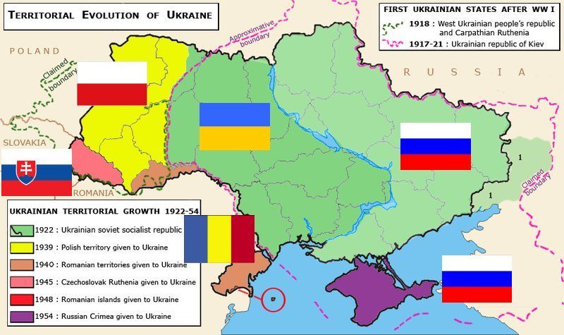
The author of the post we are focusing on, is not familiar with Ukraine, and thus, does not realize that in the upper right corner of the published map, two Ukrainian states are mentioned, which briefly became independent after the fall of the Russian and Austro-Hungarian Empires in 1918: The Ukrainian People’s Republic and the Western Ukrainian National Republic, which then united. It is proof that the Ukrainians fought for liberation and unification, which the post conceals. That independent and united Ukraine was then attacked by Soviet Russia and Poland, so most of Ukraine came under Soviet rule, and the western part — under Polish rule, as shown on the map in the post, however, not explained.
In 1939, Moscow and Hitler divided Poland, after which Moscow annexed Western Ukraine into Soviet Ukraine, not to liberate the Western Ukrainians, but to subjugate them, which crated revolt among the population. This is where the narrative emerged that Moscow gave territories to the Ukrainians, for which they were deemed ungrateful. However, what is overlooked is the fact that the Ukrainians themselves fought for those territories, as we have already mentioned.
Let us compare that with North Macedonia, which was also once under foreign rule. Would it be appropriate for someone to wave at us with a map from the Ottoman Empire or the Vardar Banovina? And is it appropriate to say that the Great Serbian conquerors liberated Vardar Macedonia from the Ottomans and gave it to us “on a silver platter”? What about the Ilinden Uprising and all those victims? This is how Moscow treats Ukrainian history, and so does the post.
The post also indicates that the Transcarpathian Region of Ukraine once belonged to Hungary or Czechoslovakia. This is true, however, the Ukrainians also established a state there, albeit again short-lived, Carpathian Ukraine, in 1939. They also had other (so-called) “Krushevo Republics” such as the Komancza Republic and the Hutsul Republic (1918-1919). A lot can be said here, but, in short, wherever there were Ukrainians, there was also their national movement, uprisings, etc.
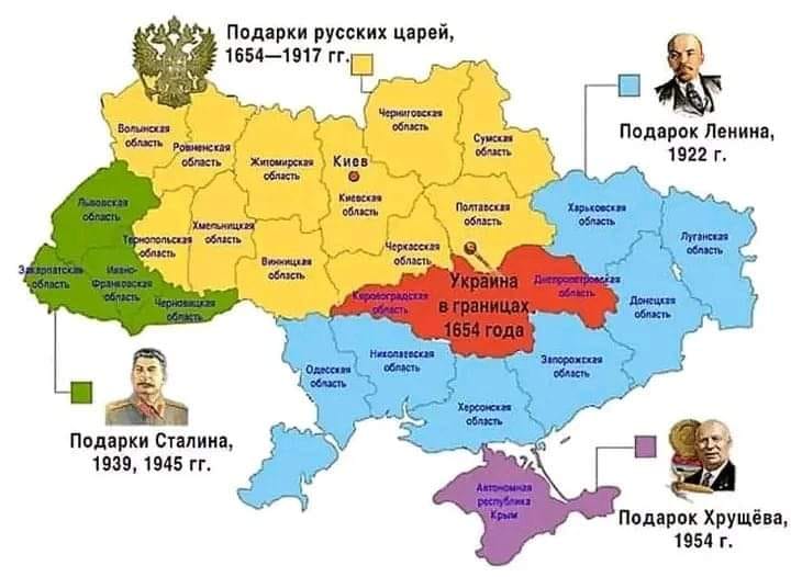
The map in the post shows that a large part of Ukraine was once under Russian rule, but it does not explain how that happened and the map is also a bit poorly designed. Previously, it was under Polish rule, which was driven out by the Ukrainian Cossacks of Bohdan Khmelnytsky, who then created a state, which lost its independence due to the harmful alliance treaty with Russia in 1654.
It concerned what is now Central Ukraine, and the Russians later also occupied what is now its south and east. It was then a sparsely populated steppe, known as the Wild Fields, after which British entrepreneurs built the cities of Donetsk and Luhansk. However, according to the 1897 census, the majority of the population in those areas was still Ukrainian. Whoever ruled the region, Ukrainians were certainly present.
The Russians also annexed Crimea in 1783, while the map in the post gives the impression that it has always been Russian territory, given to Ukraine in 1954. However, before the Russian conquest, the state of the Crimean Tatars existed there. Under Russian rule, they were oppressed and became a minority in their own country, which is why they want to be part of Ukraine. In 1918 the Ukrainian army, together with the Crimean Tatars, briefly expelled the Russian government from Crimea, but the post conceals that as well.
Also, the handover of Crimea from Russia to Ukraine in 1954 was not the only case of changing borders between Soviet republics. During those demarcations, Ukrainians also lost territories they considered their own, which ended up in Russia (Taganrog, Belgorod, etc.).
Pursuant to the Budapest Memorandum of 1994, Ukraine surrendered its Soviet nuclear weapons to Russia, while Russia pledged to respect Ukraine’s sovereignty, in that context, any disagreements were meant to be resolved. However, in 2014 Russia launched an aggression and started waving historical maps, which, as we explained, are in no way an excuse or an argument.
Finally, the most famous example of a state created from foreign and seized territories, is Russia, namely: Tatarstan, Bashkortostan, Udmurtia, Circassia, Chechnya, Dagestan, Altai, Buryatia, Yakutia, Chukotka, etc. Kaliningrad was once the German Königsberg (“King’s Mountain”), a good part of what is present-day Karelia belonged to Finland, part of the Kuril Islands and Sakhalin were Japanese, Vladivostok was Chinese, etc.
Considering all of this, we asses that the post is silent on a number of important facts, fostering a fallacious belief among the public, i.e., we assess that the post is missing context.
